Kharpocho,

GB
Skardu Fort or Kharpocho (Balti: کھر فچو) means The king of Forts is a fort in Skardu city in Gilgit-Baltistan region of Pakistan administered Kashmir. Australian mountaineer and film maker Greg Child writes that the fort is "perched above the junction of the rivers" and overlooks the Rock of Skardu.
History
The fort was originally the residence of the Rajas of Skardu who find their descent from a fakir. The fort was built by the king Ali Sher in the end of the sixteenth century.[2] General Zorawar Singh of the Dogra Rajput clan working under Maharaja Gulab Singh realized the importance of the fort's location in the town and so he occupied the fort. It was part of his many military campaigns to annex the areas of Baltistan to the princely state of Jammu and Kashmir.[3] The fort was razed to the ground in 1857 under the guidance of Ranbir Singh.[4] Mughal emperor Aurangzeb also tried to occupy the fort, which went in vain.[5]

During the First Indo-Pakistani War, Pakistani platoon were deployed inside the fort for protecting the local people.[6] Also during the war the Gilgit Scouts seiged the fort to force a garrison stationed at the fort to enter and participate in the war.[7] On 11 February 1948, Indian forces battled with the Skardu garrison of the fort. After a six hour long battle between the two the attackers retreated. They again came on 14th February directing "harassing fire into the fort".[8]

American mountaineers Robert Bates and Charles Houston writes that they were "lavishly entertained" as they visited the fort.


Changa Manga,

The Changa Manga is a small town adjacent to a planted forest which includes a wildlife park, in Kasur District and Lahore District, Punjab, Pakistan. It is located appx. 80 kilometers south-west of Lahore.
Etymology
The name "Changa Manga" comes from the old story of two brother thieves, Changa and Manga, who used to hide in thick forests, along with their loots. Over the passage of time the stories have been molded into adventures that every child in that area is told, with added morals.

Forestry
The forest is entered from a road from off the N-5 Highway near Bhai Pheru and Chunian . The forest covers an area of 48.6 square kilometres (12,000 acres) and is one of the largest man-made forests on the planet. The planting and irrigation of the land took place in the 19th century under the British Raj due to the need for timber for the Indian Railways network. The most common species of trees are Dalbergia sissoo (sheesham), Acacia nilotica (kikar), both members of the Fabaceae native to the Indian subcontinent, white mulberry (Morus alba), popular in cultivation throughout South Asia, or Eucalyptus and Populus species.
article

Islam,

Islam (/ˈɪslɑːm/;[note 1] Arabic: الإسلام‎, al-ʾIslām IPA: [ælʔɪsˈlæːm] ( listen)[note 2]) is a monotheistic, Abrahamic religion articulated by the Qur'an, a religious text considered by its adherents to be the verbatim word of God (Allāh), and, for the vast majority of adherents, by the teachings and normative example (called the sunnah, composed of accounts called hadith) of Muhammad (c. 570–8 June 632 CE), considered by most of them to be the last prophet of God. An adherent of Islam is called a Muslim (sometimes spelled "Moslem").

Muslims believe that God is one and incomparable and that the purpose of existence is to worship God. Muslims also believe that Islam is the complete and universal version of a primordial faith that was revealed many times before through prophets including Adam, Noah, Abraham, Moses, and Jesus. They maintain that the previous messages and revelations have been partially misinterpreted or altered over time, but consider the Arabic Qur'an to be both the unaltered and the final revelation of God. Religious concepts and practices include the five pillars of Islam, which are basic concepts and obligatory acts of worship, and following Islamic law, which touches on virtually every aspect of life and society, providing guidance on multifarious topics from banking and welfare, to family life and the environment.

Most Muslims are of two denominations: Sunni (75–90%)[9] or Shia (10–20%). About 13% of Muslims live in Indonesia,[11] the largest Muslim-majority country, 25% in South Asia, 20% in the Middle East, and 15% in Sub-Saharan Africa.[13] Sizable Muslim communities are also found in Europe, China, Russia, and the Americas. Converts and immigrant communities are found in almost every part of the world. With about 1.62 billion followers or 23% of the global population, Islam is the second-largest religion by number of adherents and, according to many sources, the fastest-growing major religion in the world.

Brest Fortress

Brest Fortress


The Brest Fortress was the first place to be attacked by the Nazi invaders.Brest Fortress was built in 1833 - 1838, a mile west of the town of Brest. The citadel, which was the nucleusof the fortress, was situated on the island formed by the Western Bug River and branches of the Muhavets River. The 6.5 - foot thick brick wall of the cutadel served as a two-floored barrackes with five hundred casemates. Under the barrack were storehouses and a network of tunnels.Two gates, Holmskie and Brestskie, connected the citadel to a bridge over the Muhavets. The third gate, Terespolskie, opened onto a bridge over the Western Bug. The bridges lead to the artificial islands, where the outer fortifications, Kobrinskoye on the north, Terespolskoye on the west and Volynskoye on the south, were situated. The fortress was fenced by with a 32-foot high earth wall with casemates.


Capstan

A capstan is a vertical-axled rotating machine developed for use on sailing ships to apply force to ropes, cables, and hawsers. The principle is similar to that of the windlass, which has a horizontal axle.
History
The word, connected with the Old French capestan or cabestan(t), from Old Provençal cabestan, from capestre "pulley cord," from Latin capistrum, -a halter, from capere, to take hold of, seems to have come into English (14th century) from Portuguese or Spanish shipmen at the time of the Crusades.[1] Both device and word are considered Spanish inventions.

Deosoi,,,

GB

about
He is a admin of blog (theworldsifo.blogspot.com) and the places is deosoi .this is a very beautiful place in the world & travelling places. 
this place is around the north of pakistan.........................................................................................

Easter Island

Easter Island (Rapa Nui: Rapa Nui, Spanish: Isla de Pascua) is a Polynesian island in the southeastern Pacific Ocean, at the southeasternmost point of the Polynesian Triangle. Easter Island is famous for its 887 extant monumental statues, called moai, created by the early Rapa Nui people. In 1995, UNESCO named Easter Island a World Heritage Site, with much of the island protected within Rapa Nui National Park.

Polynesian people settled on Easter Island in the first millennium CE, and created a thriving culture, as evidenced by the moai and other artifacts. However, human activity, the introduction of the Polynesian rat and overpopulation led to gradual deforestation and extinction of natural resources, which caused the demise of the Rapa Nui civilization.[5] By the time of European arrival in 1722, the island's population had dropped to 2,000–3,000 from a high of approximately 15,000 just a century earlier. Diseases carried by European sailors and Peruvian slave raiding of the 1860s further reduced the Rapa Nui population, down to 111 in 1877.

Villarrica

About
Villarrica is one of Chile's most active volcanoes, rising above the lake and town of the same name. The volcano is also known as Rucapillán, a Mapuche word meaning "House of the Pillán". It is the westernmost of three large stratovolcanoes that trend perpendicular to the Andean chain along the Gastre Fault. Villarrica, along with Quetrupillán and the Chilean portion of Lanín, are protected within Villarrica National Park. Ascents of the volcano are popular with several guided ascents reaching the top during summer.


Patagonia , Chile , Argentina

Patagonia is a sparsely populated region located at the southern end of South America, shared by Argentina and Chile. The region comprises the southern section of the Andes mountains as well as the deserts, steppes and grasslands east of this southern portion of the Andes. Patagonia has two coasts; a western one towards the Pacific Ocean and an eastern one towards the Atlantic Ocean.


Fricks Cave Walker County

About
Walker County is a county located in the U.S. state of Georgia. As of the 2010 census, the population was 68,756. The county seat is LaFayette. The county was created on December 18, 1833 from land formerly belonging to the Cherokee Indian Nation.

Walker County is part of the Chattanooga, TN–GA Metropolitan Statistical Area.

Walker County is one of only nine counties in the United States still employing the sole commissioner form of government.
Article wiki
Image Source 


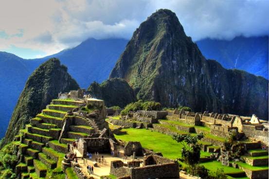
Machu Picchu, Peru

Source Link
About
Machu Picchu (in hispanicized spelling, Spanish pronunciation: [ˈmatʃu ˈpiktʃu]) or Machu Pikchu (Quechua machu old, old person, pikchu peak; mountain or prominence with a broad base which ends in sharp peaks,[1] "old peak", pronunciation [ˈmɑtʃu ˈpixtʃu]) is a 15th-century Inca site located 2,430 metres (7,970 ft) above sea level.[2][3] It is located in the Cusco Region, Urubamba Province, Machupicchu District in Peru.[4] It is situated on a mountain ridge above the Sacred Valley which is 80 kilometres (50 mi) northwest of Cusco and through which the Urubamba River flows. Most archaeologists believe that Machu Picchu was built as an estate for the Inca emperor Pachacuti (1438–1472). Often mistakenly referred to as the "Lost City of the Incas", it is the most familiar icon of Inca civilization.

The Incas built the estate around 1450, but abandoned it a century later at the time of the Spanish Conquest. Although known locally, it was unknown to the outside world before being brought to international attention in 1911 by the American historian Hiram Bingham. Since then, Machu Picchu has become an important tourist attraction. Most of the outlying buildings have been reconstructed in order to give tourists a better idea of what the structures originally looked like.[5] By 1976, thirty percent of Machu Picchu had been restored.[5] The restoration work continues to this day.[6]

Since the site was not known to the Spanish during the colonial period, it is highly significant as a relatively intact cultural site. Machu Picchu was declared a Peruvian Historical Sanctuary in 1981 and a UNESCO World Heritage Site in 1983.[3] In 2007, Machu Picchu was voted one of the New Seven Wonders of the World in a worldwide Internet poll.

Machu Picchu was built in the classical Inca style, with polished dry-stone walls. Its three primary structures are the Inti Watana, the Temple of the Sun, and the Room of the Three Windows. These are located in what is known by archaeologists as the Sacred District of Machu Picchu.[citation needed]

Machu Picchu is vulnerable to threats. While natural phenomena like earthquakes and weather systems can play havoc with access, the site also suffers from the pressures of too many tourists. In addition, preservation of the area's cultural and archaeological heritage is an ongoing concern.
&


Ayacucho

About
Ayacucho (Spanish pronunciation: [aʝaˈkutʃo], Quechua: Ayacuchu), also known as Huamanga, is the capital city of Huamanga Province, Ayacucho Region, Peru.

Ayacucho is famous for its 33 churches, which represent one for each year of Jesus' life. Ayacucho has large religious celebrations, especially during the Holy Week of Easter. These celebrations include horse races featuring Peruvian Caballos de Paso and the traditional running of the bulls, known locally as the jalatoro or pascuatoro. The jalatoro is similar to the Spanish encierro, except that the bulls are led by horses of the Morochucos.


The name is derived from the Quechua words aya (death) and kuchu ("corner"), referring to a major battle for independence. Another possible interpretation is "soul or spirit corner," in reference to the great devotion of its people, even in pre-Hispanic times.

The Dunes in Peru

About
In physical geography, a dune is a hill of sand built by either wind or water flow. Dunes occur in different shapes and sizes, formed by interaction with the flow of air or water. Most kinds of dunes are longer on the windward side where the sand is pushed up the dune and have a shorter "slip face" in the lee of the wind. The valley or trough between dunes is called a slack. A "dune field" is an area covered by extensive sand dunes. Large dune fields are known as ergs.

Lima

About
Lima /ˈliːmə/ is the capital and the largest city of Peru. It is located in the valleys of the Chillón, Rímac and Lurín rivers, in the central coastal part of the country, overlooking the Pacific Ocean. Together with the seaport of Callao, it forms a contiguous urban area known as the Lima Metropolitan Area. With a population approaching 9 million, Lima is the most populous metropolitan area of Peru, and the fifth largest city in the Americas (as defined by "city proper").

Lima was founded by Spanish conquistador Francisco Pizarro on January 18, 1535, as Ciudad de los Reyes. It became the capital and most important city in the Spanish Viceroyalty of Peru. Following the Peruvian War of Independence, it became the capital of the Republic of Peru. Today, around one-third of the Peruvian population lives in the metropolitan area.

Lima is home to one of the oldest higher learning institutions in the New World. The National University of San Marcos, founded on May 12, 1551 during Spanish colonial regime, is the oldest continuously functioning university in the Americas.

Lake Titicaca , Peru

Titicacaor Titiqaqa  is a lake in the Andes on the border of Peru and Bolivia. By volume of water, it is the largest lake in South America. Lake Maracaibo has a larger surface area, though some consider it to be a large brackish bay due to its direct connection with the sea.

It is often called the highest navigable lake in the world, with a surface elevation of 3,812 metres . Although this refers to navigation by large boats, it is generally considered to mean commercial craft. For many years the largest vessel afloat on the lake was the 2,200-ton, 79-metre SS Ollanta. Today the largest vessel is probably the similarly sized, but broader, train barge/float Manco Capac, operated by PeruRail. At least two dozen bodies of water around the world are at higher elevations, but all are much smaller and shallower.


Liege

About
Liege, the largest French-speaking city in Belgium after Brussels, is a historical city situated along the Meuse River. In the fall of 2009, the city welcomed the opening of a stunning, new train station, which brings visitors to Liege from Brussels in 1 hour, Maastrict, Holland in 20 mins and Paris in 2 hours. Designed by the world-renowned architect Santiago Calatrava, it’s a prime example of Liege’s modern transformations.

Dating back to Charlemagne, Liege is a treasure trove of historical sites and celebrated collections. Sitting on the Meuse River is the Grand Curtius, home to the prestigious archaeology, decorative arts, religious and Mosan art museums, a glass museum as well as the famous weaponry museum. Travel back in time as you walk the Coteaux, a winding path of steps and courtyards leading up to the citadel of Liege with an incredible view. Just outside the city, visitors have easy access to the Blegny mines and the Henri Chapelle American Military cemetery, the largest in Belgium. The city will host the opening leg of the Tour de France this summer!

Leuven

About
The capital of the Flemish Brabant Province is none other than that of Leuven. It is a historical city with a rich and colorful history. It is also home to one of the largest brewers in the world; Anheuser-Busch. It is also home to the oldest university in Belgium. The Katholieke Universiteit is considered to be the oldest Catholic university in the world.

Bruge

About
Bruges (/ˈbruːʒ/ in English; Dutch: Brugge [ˈbrʏɣ̟ə]; French: Bruges [ˈbʁyːʒ]; German: Brügge [ˈbrʏɡə]) is the capital and largest city of the province of West Flanders in the Flemish Region of Belgium. It is located in the northwest of the country.

The area of the whole city amounts to more than 13,840 hectares, including 1,075 hectares off the coast, at Zeebrugge (from Brugge aan zee[2] meaning "Bruges on Sea"[3]). The historic city centre is a prominent World Heritage Site of UNESCO. It is oval-shaped and about 430 hectares in size. The city's total population is 117,073 (1 January 2008),[4] of which around 20,000 live in the city centre. The metropolitan area, including the outer commuter zone, covers an area of 616 km2 (238 sq mi) and has a total of 255,844 inhabitants as of 1 January 2008.[5]
Artical link

Brussels

About
Brussels is quickly gaining a reputation as one of Europe’s must-see destinations. With its central location in the heart of Europe, Brussels is easily accessible by air or high-speed rail from neighboring countries. It is an international metropolis – a mosaic of languages, cultures, and traditions – and the home of the European Union, NATO and hundreds of international organizations, English is widely spoken, making it a great place for even a novice French-speaker to get by without an issue.


Brussels is a classic European city with small town charm and cosmopolitan attractions. Among the most celebrated attractions are the Grand Place, Europe’s most beautiful medieval square lined with guild houses. Originally built in the 13th century, the square is a UNESCO World Heritage Site. Every other year for two days (it will occur be in 2012) the Grand’Place is decked out in an amazing flower carpet, made up of 1 million begonias.

Just a short walk from the Grand Place is the Mannekin Pis, a small bronze statue of a little boy relieving himself. The statue, a great example of Belgium’s quirky sense of humor, is often given costumes to mark various occasions, anniversaries or events.

Mons

About
Located just 1 hour from Brussels, Mons is a city rich in history and tradition. The town hall building on the Grand Place of Mons, constructed between 1458 and 1477, has a Belfry, listed as a UNESCO World Heritage Site. Van Gogh also spent some time near Mons before moving on to Provence. His house, an authentic and preserved environment, now houses a permanent exhibition of reproductions and an audio-visual show in various languages, including English.

The most important event of the year, however, is the Ducasse de Mons or the Doudou, dating back to 1349 and the Fraternity of Saint George. Each June, the city of Mons is filled with visitors who come to witness the reenactment of Saint George slaying the Dragon. As the dragon swings its tail at the crowd, spectators try to grab the tail and pull out its hair and ribbons, both of which bring good luck. This popular festival is recognized by UNESCO as a Masterpiece of the Oral and Intangible Heritage of Humanity. In 2015 Mons will be the European Capital of Culture.


Bruges , Belgium

Image | Link
While Bruges has become more of a destination since the release of the film In Bruges in 2008, the city still lies in the shadows of Antwerp and Brussels when it comes to Belgian destinations. This historic port city is best known for its medieval architecture and numerous canals and sometimes dubbed “The Venice of the North.” Michelangelo’s Madonna and Child sculpture is located in Bruges.

Article | Link


Monal (Islamabad)

about
monal is a rapidly developing tourist resort located 17 kilometers (11 mi) from Islamabad on top of Margalla Hills. It has a 3000 plus ft elevation and located in Monal village which is geographically part of Haripur District.

Shahdara (islaamabad)

information
Shahdara Village is situated in sub-rubs of Margalla Hills of Islamabad. It is 10 km away from President House in North-East and in the North of Barakhao. The well-known Quaid-e-Azam University of Islamabad is near Shahdara Village. Climate of Shahdara is same as of Islamabad that is, Winter from Nov to Feb, Spring from March to April, Summer from May to June, Rainy Monsoon (July−August) and Autumn (September−October).

Amsterdam

Herengracht, Keizersgracht, and Prinsengracht are the three primary canals in Amsterdam, and these concentric belts form a circle around the city and are where most of the action takes place. With over 1500 fabulous monumental buildings and just as many bridges, visitors to Amsterdam spend much of their time exploring the eccentricities and marvelous museums dotting the 60 miles of canals across the city. The Anne Frank House and the Rijksmuseum Museum are the most popular stops for history and art seekers, while the Prinsengracht area is one of the best places for shopping, gallery viewing, pub crawling, and checking out the unique coffee shops in Amsterdam.
&

Neela Sandh

information
Neela Sandh is in Mori Syedan, Tehsil Kotli Satian, District Rawalpindi, Pakistan. Its almost 40 km away from Pakistan capital city Islamabad. Neela Sandh comprises a series of attractive ponds of crystal clear bluish water along lush green valleys.

British Virgin Islands , UK

\
The Virgin Islands, commonly known as the British Virgin Islands  is a British overseas territory located in the Caribbean to the east of Puerto Rico. The islands make up part of the Virgin Islands archipelago, the remaining islands constitute the US Virgin Islands and the Spanish Virgin Islands. The official name of the Territory is still simply the "Virgin Islands", but the prefix "British" is often used to distinguish it from the neighbouring American territory which changed its name from the "Danish West Indies" to "Virgin Islands of the United States" in 1917. British Virgin Islands government publications continue to begin with the name "The Territory of the Virgin Islands", passports simply refer to the "Virgin Islands", and all laws begin with the words "Virgin Islands". Moreover, the Territory's Constitutional Commission has expressed the view that "every effort should be made", to encourage the use of the name "Virgin Islands".[5] The British Virgin Islands consist of the main islands of Tortola, Virgin Gorda, Anegada, and Jost Van Dyke, along with over fifty other smaller islands and cays. About 15 of the islands are inhabited. The capital, Road Town, is situated on Tortola, the largest island, which is approximately 20 km (12 mi) long and 5 km (3 mi) wide. The islands have a population of about 27,800, of whom approximately 23,000 live on Tortola.


Giant's Causeway

About
The Giant's Causeway (known as Clochán an Aifir or Clochán na bhFomhórach in Irish[1] and tha Giant's Causey in Ulster-Scots)[2] is an area of about 40,000 interlocking basalt columns, the result of an ancient volcanic eruption.[3]

It is located in County Antrim on the northeast coast of Northern Ireland, about three miles (4.8 km) northeast of the town of Bushmills. It was declared a World Heritage Site by UNESCO in 1986, and a national nature reserve in 1987 by the Department of the Environment for Northern Ireland. In a 2005 poll of Radio Times readers, the Giant's Causeway was named as the fourth greatest natural wonder in the United Kingdom.[4] The tops of the columns form stepping stones that lead from the cliff foot and disappear under the sea. Most of the columns are hexagonal, although there are also some with four, five, seven or eight sides. The tallest are about 12 metres (39 ft) high, and the solidified lava in the cliffs is 28 metres (92 ft) thick in places.

Mourne Mountains


About
The Mourne Mountains /ˈmɔərn/ mohrn, also called the Mournes or Mountains of Mourne, (Irish – na Beanna Boirche) are a granite mountain range in County Down in the south-east of Northern Ireland. It includes the highest mountains in Northern Ireland and the province of Ulster. The highest of these is Slieve Donard at 850 metres (2,790 ft). The Mournes is an area of outstanding natural beauty and has been proposed as the first national park in Northern Ireland. The area is partly owned by the National Trust and sees a large number of visitors every year. The name Mourne (historically spelt Morne) is derived from the name of a Gaelic clann or sept called the Múghdhorna.


Dartmoor

About
Dartmoor is an area of moorland in south Devon, England. Protected by National Park status as Dartmoor National Park, it covers 954 square kilometres (368 sq mi).[1]

The granite which forms the uplands dates from the Carboniferous Period of geological history. The moorland is capped with many exposed granite hilltops known as tors, providing habitats for Dartmoor wildlife. The highest point is High Willhays, 621 m (2,037 ft) above sea level. The entire area is rich in antiquities and archaeology.

Edinburgh , UK

information
Visitors to Edinburgh need to be prepared to experience history, from the cobblestone streets to Edinburgh Castle that is symbolic of Scotland’s capital. Edinburgh is steeped in history, beginning with the Old and New Towns, which have more than 4,500 historic buildings and sites between them. Old Town is home to Edinburgh’s most famous street, the Royal Mile that connects Edinburgh Castle with the Palace of Holyroodhouse. New Town isn’t really new, since it dates back to the 18th century and is best known for its neoclassical architecture.


Chinese Garden Of Serenity

information
Here, you’ll find the perfect venue to soak up some tranquillity in this wonderful public space. Its most striking elements are created from rocks and water, and the use of such base elements is intended to transport you to the basic elements of nature, yin and yang. Or at least that’s how it works if you believe the official blurb!
&


Inland Sea

On the surface of things (pardon the pun) it seems unlikely that this small inland saltwater lake, joined to the sea only by a tunnel accessed through a small archway, should be worthy of such a lofty accolade.

Most of the time when you come here it will be deserted and almost always quiet, unless there’s a fisherman trying to guide his boat out to sea for a day’s work, or a dive school eagerly preparing to be amazed as they get instructions before taking to the water.
&


Gozo,

Compared to some ‘lively’ European holiday destinations, Malta is pretty laid back. There is a bustling night scene if you want it but you have to go looking for it so most visitors enjoy a quiet and relaxing stay. Malta’s prevailing peace, however, is nothing compared to sister island Gozo … because if Malta is laid-back, then this place is positively flat out!
&

Mdina

Mdina is known as the jewel in the crown of Malta and it is a fair assessment. The walled city is full of tiny alleys which you can wind your way through, stumbling across beautiful churches and museums along the way. Now effectively part of the town of Rabat, this definitely shouldn’t be left off your Maltese itinerary.

Marsaxlokk, Malta

information
The vibrant trading port of Marsaxlokk was established in 900 BC when the Phoenicians first landed on Malta. Today, this picturesque town is the main supplier of fish to the island nation that sits in the Mediterranean Sea. It’s well known for its massive markets that are stocked with an extensive array of fish, including the local favorite, Lampuki. This is a rare Maltese seaside village in that it has no modern buildings to spoil its appeal. With such tranquil surroundings, including the traditional luzzu’s (fishing boats) that are built according to a design that dates back to the time of the Phoenicians, it’s a particularly charming place to visit.


Malmö , Sweden

Information
Malmö is the biggest city in Skåne and a multi-cultural place full of energy. In recent years, Malmö has developed into an exciting city with a focus on cultural offerings, innovative architecture and a strong organic social character. Malmö was certified as Sweden’s first Fairtrade City in 2006 and this has spurred the city’s organic and fair trade offerings. In Malmö, it’s easy to shop with a clear conscience and to enjoy ethically produced food and drink. Here, you can dine at one of Sweden’s most acclaimed organic restaurants and shop for the latest fashions made with the environment and ethics clearly in mind.


Stockholm Archipelago , Sweden

Information
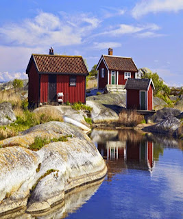
One of the most fantastic parts of Stockholm and Sweden is still a secret for many — the magnificent Stockholm archipelago. This maritime landscape of more than 30,000 islands, islets and skerries, of which just some one thousand are inhabited, is unique in the world both in summer and winter.


Drottningholm , Sweden

information

 Drottningholm Palace on the island of Lovö is a UNESCO World Heritage Site and lies about 11 kilometers west of Stockholm city center (45 minutes by boat). Dating from the 17th century, the palace is now the official residence of the Swedish Royal Family. In the picturesque, terraced park are bronze sculptures from Bohemia and Denmark, brought back as trophies of war. Be sure to take in the Chinese Pavilion which dates from the late 1700s. The 18th-century Palace Theatre (Drottningholms Slottsteater) is still used for performances during the summer months. In the Theatre Museum, you can see period stage costumes and stage scenery.


Stockholm , Sweden

Stockholm is the capital of Sweden and the most populous city in the Nordic region, with 911 989 people living in the municipality,approximately 1.4 million in the urban area, and a total population close to 2.2 million in the metropolitan area.The city is spread across 14 islands on the coast in the southeast of Sweden at the mouth of Lake Mälaren, by the Stockholm archipelago and the Baltic sea. The area has been settled since the Stone Age, in the 6th millennium BC, and was founded as a city in 1252 by Birger Jarl.

Stockholm is the cultural, media, political, and economic centre of Sweden. The region alone accounts for over a third of the country's GDP, and is among the top 10 regions in Europe by GDP per capita. It's an important global city, and the main centre for corporate headquarters in the Nordic region. The city is home to some of Europe's top ranking universities, such as the Karolinska Institute, and hosts the annual Nobel Prize ceremonies and banquet at the Stockholm Concert Hall and Stockholm City Hall. One of the city's most prized museums, the Vasa Museum, is the most visited non-art museum in Scandinavia. The Stockholm metro, opened in 1950, is well known for its decoration of the stations; it has been called the longest art gallery in the world.Sweden's national football arena is located north of the city centre, in Solna. Ericsson Globe, the national indoor arena, is in the southern part of the city. The city was the host of the 1912 Summer Olympics, and hosted the equestrian portion of the 1956 Summer Olympics otherwise held in Melbourne, Australia.

Dougga , Tunisia

Information
Dougga or Thugga  is an ancient Roman city in northern Tunisia, included in a 65 hectare archaeological site.

UNESCO qualified Dougga as a World Heritage Site in 1997, believing that it represents “the best-preserved Roman small town in North Africa”. The site, which lies in the middle of the countryside, has been protected from the encroachment of modern urbanisation, in contrast, for example, to Carthage, which has been pillaged and rebuilt on numerous occasions.

Thugga’s size, its well-preserved monuments and its rich Numidian-Berber, Punic, ancient Roman and Byzantine history make it exceptional. Amongst the most famous monuments at the site are a Punic-Libyan mausoleum, the capitol, the theatre, and the temples of Saturn and of Juno Caelestis.

Image | Link
Article | Link

Tunis,Tunisia

Information
About
Tunis (Arabic: تونس‎ Tūnis; Amazigh: Tunes, ⵜⵓⵏⴻⵙ) is the capital of Tunisia. It is Tunisia's largest city, with a population of 651,183 as of 2013. The greater metropolitan area holds some 2,300,000 inhabitants.

Situated on a large Mediterranean Sea gulf (the Gulf of Tunis), behind the Lake of Tunis and the port of La Goulette (Halq al Wadi), the city extends along the coastal plain and the hills that surround it. At the centre of more modern development (from the colonial era and later) lies the old medina. Beyond this district lie the suburbs of Carthage, La Marsa, and Sidi Bou Said.

Just through the Sea Gate (also known as the Bab el Bahr and the Porte de France) begins the modern city, or Ville Nouvelle, transversed by the grand Avenue Habib Bourguiba (often referred to by popular press and travel guides as "the Tunisian Champs-Élysées"), where the colonial-era buildings provide a clear contrast to smaller, older structures. As the capital city of the country, Tunis is the focus of Tunisian political and administrative life; it is also the centre of the country's commercial activity. The expansion of the Tunisian economy in recent decades is reflected in the booming development of the outer city where one can see clearly the social challenges brought about by rapid modernization in Tunisia.

Carthage , Tunisia

The city of Carthage  is a city in Tunisia and was the centre of the ancient Carthaginian civilization. The city developed from a Phoenician colony of the 1st millennium BC into the capital of an ancient empire.[2] The area of Carthage was before inhabited by Berber people who also became the bulk of Carthage's population and constituted a significant part of its army, economy and administration. Native Berbers and settling Phoenicians in Carthage mixed in different ways including religion and language, creating the Punic language and culture.citation needed

The name of Carthage, Latin: Carthago or Karthago, Ancient Greek: Καρχηδών Karkhēdōn, Etruscan: *Carθaza, is derived from the Phoenician ������ �������� Qart-ḥadašt meaning "New City", implying it was a 'new Tyre'.


Popular Posts

Like us on Facebook

Flickr Images